
DNS-Doppler Navigation System: Basics and Functionality
Advertisement
The DNS avionic system, short for Doppler Navigation System, is a long-range navigational aid used in aviation.
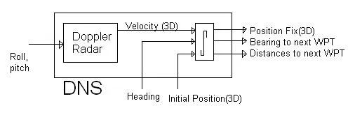
The DNS system provides aircraft velocity (3D) and position fix (3D) information. It is primarily used for military purposes requiring high-speed, low-altitude flights. The system determines the aircraft’s velocity using Doppler radar, and this information is fed into a navigation computer to calculate the position fix. Like INS (Inertial Navigation System), DNS is a self-contained system, meaning it doesn’t rely on any external sources.
The system includes the following features when installed in the aircraft:
- The transmitter (Tx) and receiver (Rx) are part of the DNS radar system.
- It operates at SHF (Super High Frequency) bands (8.8 to 9.8 GHz and 13.25 to 13.40 GHz).
- The aircraft’s Doppler radar transmits a beam towards the ground.
- The beam is reflected and observed at the aircraft receiver, providing velocity information.
- Velocity is then integrated to determine the position.
Advantages
- DNS is a self-contained airborne system that doesn’t require any external navigation sources.
- It operates effectively over both land and water.
- The average velocity information is highly accurate.
- The aircraft’s transmitter and receiver are light, small, and inexpensive due to their low power requirements.
- Sometimes, a combination of INS and DNS is used for more accurate readings. One technology can correct the other because:
- INS can generate short-term velocity errors.
- DNS can generate long-term velocity errors.
Disadvantages
- 3D velocities are initially obtained in aircraft coordinates and then transformed to earth coordinates, which can introduce calculation errors. The overall system error is approximately 0.5%.
- DNS performance is reduced in extreme weather conditions, such as heavy rain.
- When operating over water, accuracy can be degraded due to water motion and smooth water surfaces.
Continue Learning Radio Navigation Systems (VOR, DME, TACAN & More)
Deep dives into the radio-based beacons, direction finders, and navigation systems that have guided aircraft for decades.
- ADF (Automatic Direction Finder) Basics
- VOR (VHF Omnidirectional Range) Basics
- DME (Distance Measuring Equipment) Basics
- TACAN (Tactical Air Navigation) System Basics
- VORTAC (VOR + TACAN) Navigation
- DME vs TACAN Air Navigation
- RNAV (Random or Area Navigation)
- LORAN (Long Range Navigation) Basics
- OMEGA Navigation System
- DNS (Doppler Navigation System)
- INS (Inertial Navigation System)
- Dead Reckoning Navigation System Basics
- Dead Reckoning Navigation Method
Precision Landing Systems
Explore More Aeronautical Communications & Satellite Navigation Fundamentals
- Air Traffic Management Explained: A Deep Dive into ATM & LDACS
- AeroMAC: Aeronautical Mobile Airport Communications System
- Avionic Systems & Navigational Aids
- B-AMC: Broadband Aeronautical Multi-Carrier Communication
- What is DGPS (Differential Global Positioning System)?
- GNSS vs GPS: Understanding the Difference
- Satellite Navigation: Advantages & Disadvantages