
GIS vs. Remote Sensing: Key Differences Explained
By RF Wireless Expert Team
Advertisement
This article explores the differences between GIS (Geographical Information System) and Remote Sensing.
GIS stands for Geographical Information System. Remote sensing, on the other hand, typically involves using satellites.
What is GIS (Geographical Information System)?
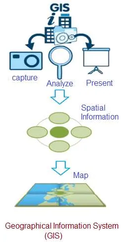
A GIS is a powerful tool for managing and analyzing geographic data.
- It’s a software program that allows users to store and manipulate large amounts of data from GPS and other sources.
- GIS are software systems capable of input, storage, manipulation, and analysis.
- It displays geographic (spatial) information in various output formats such as maps, graphs, or charts.
- Essentially, it’s a system that deals with all types of geographically referenced data.
- GIS software runs on everything from powerful servers to mobile devices.
- There are three common ways spatial data is represented in GIS: vector, raster, and triangulated.
.
What is Remote Sensing?
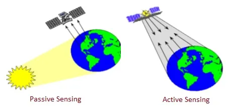
Remote sensing uses satellites and aircraft to gather information about the Earth.
- Remote sensing involves using satellites or aircraft to capture information about the Earth’s surface.
- Remote sensing satellites are valuable for gathering information about objects (i.e., the Earth) from a distance.
- There are two main types of remote sensing: active and passive.
- It’s the science of deriving information about an object by taking measurements from a distance. Most remote sensing systems use electromagnetic energy that comes from the objects being observed.
Continue Learning Remote Sensing Technology
- Remote Sensing Basics : Satellite Radiometer
- Remote Sensing : Major Applications & Advancements
- Difference between Active and Passive Remote Sensing
- Remote Sensing Use Case : Environment-Temperature Monitoring
Explore Satellite Communication Technology Resources
- Satellite Communication Basics Tutorial
- GEO Vs. LEO Vs. MEO Satellite Types
- Apogee and Perigee in Satellite Communication
- Satellite Capacity Allocation Types
- Satellite Frequency Bands
- Satellite Transponder Components & its function
- Satellite Bus vs Payload : Understand functions
- Satellite Ground Station Basics
- Satellite System Security Mechanisms & Standards
- Satellite Parking Lot Concepts and Procedures
- Satellite Launching Procedure and Processes
- Telemetry, Tracking and Command (TTC) in Satellite System