
LDACS2 Physical Layer Overview
Advertisement
LDACS2 is a proposed L-band Digital Aeronautical Communication System designed for communication between Aircraft Stations (ASs) and Ground Stations (GS). It employs a single-carrier technology and operates based on the Time Division Duplexing (TDD) topology. The system operates within the frequency band of 960MHz to 975 MHz.
Since the physical layer operates on the TDD concept, transmissions from ASs and GSs are time-multiplexed at the same carrier frequency. This can be understood by examining the LDACS2 frame structure. It is recommended to review LDACS1 physical layer before diving into LDACS2 PHY to understand the concept thoroughly.
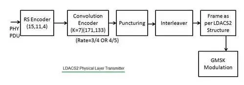 Figure-1 depicts LDACS2 physical layer Transmitter.
As shown in the figure, data goes through several steps. In general, the physical layer transmitter consists of an RS Encoder, Convolution encoder, puncturing, interleaver, frame formation and GMSK modulation, similar to what is used in the GSM standard.
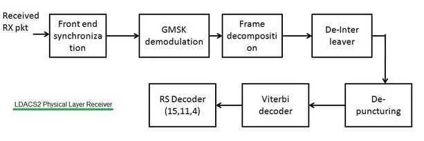 LDACS2 physical layer receiver
In general, the LDACS2 physical layer receiver consists of front-end synchronization (Time, frequency, and channel), GMSK demodulation, frame decomposition, deinterleaver, depuncturing, Viterbi decoder, and RS Decoder.
Continue Learning LDACS Frame Structure & Physical Layer & Air Traffic Management
- Air Traffic Management & LDACS Overview
- LDACS1 Frame Structure
- LDACS1 Physical Layer
- LDACS2 Frame Structure
- LDACS1 vs LDACS2: Understanding the Differences
Explore Radio Navigation Systems (VOR, DME, TACAN & More)
Deep dives into the radio-based beacons, direction finders, and navigation systems that have guided aircraft for decades.
- ADF (Automatic Direction Finder) Basics
- VOR (VHF Omnidirectional Range) Basics
- DME (Distance Measuring Equipment) Basics
- TACAN (Tactical Air Navigation) System Basics
- VORTAC (VOR + TACAN) Navigation
- DME vs TACAN Air Navigation
- RNAV (Random or Area Navigation)
- LORAN (Long Range Navigation) Basics
- OMEGA Navigation System
- DNS (Doppler Navigation System)
- INS (Inertial Navigation System)
- Dead Reckoning Navigation System Basics
- Dead Reckoning Navigation Method