 RF
RFSatellite Imaging: Types, Applications, and Benefits
Advertisement
Satellite imaging involves capturing images of the Earth or other celestial bodies using satellites equipped with sensors. These sensors collect data across various wavelengths of the electromagnetic spectrum, including visible light, infrared, and microwave. Due to its sensing method, it is also known as remote sensing. The collected data is then processed to create images that can be analyzed for a wide range of applications.
Let’s explore satellite imaging system components, types, applications, benefits, limitations, and examples.
Key Components of Satellite Imaging
The satellite imaging system consists of three main components:
-
Satellites
-
Sensors
-
Data processing module
-
Satellites: These are placed in different orbits (e.g., geostationary, polar, sun-synchronous) depending on the imaging requirements. These orbits determine the coverage area, revisit frequency, and resolution of the images.
-
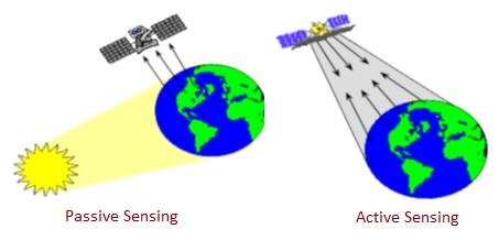
Sensors: Satellites carry sensors that can be passive (detecting natural radiation) or active (emitting signals and measuring the reflection). The figure depicts active and passive satellite imaging types. Common types of sensors include:
- Optical Sensors: Capture images in visible and near-infrared wavelengths.
- Radar Sensors: Use microwave signals to penetrate clouds and capture images in all weather conditions.
- Thermal Sensors: Measure infrared radiation to determine temperature variations.
-
Data Processing: Raw data collected by the sensors is processed to correct distortions, calibrate the images, and enhance the quality. This processed data is then used to create images for analysis.
Satellite Imaging Types with Examples
Satellite imaging encompasses various techniques and sensor types, each suited for specific applications and purposes. The main types of satellite imaging include the following:
-
Optical Imaging:
- Visible Light Imaging: Captures images in the visible spectrum (400-700 nm), similar to what the human eye can see.
- Multispectral Imaging: Captures data across multiple wavelengths, including visible, near-infrared, and shortwave infrared bands. Examples include Landsat and Sentinel-2 satellites.
- Hyperspectral Imaging: Captures data in many narrow spectral bands across a wide range of wavelengths, providing detailed spectral information. Examples include NASA’s Hyperion instrument.
-
Infrared Imaging:
- Near-Infrared (NIR) Imaging: Captures images in the near-infrared spectrum (700-1400 nm), useful for vegetation and water body analysis.
- Thermal Infrared Imaging: Measures emitted infrared radiation to detect temperature variations, useful for studying heat patterns, volcanic activity, and urban heat islands. Examples: Landsat thermal infrared sensor (TIRS).
-
Radar Imaging (Synthetic Aperture Radar):
- Uses microwave signals to create images, capable of penetrating clouds and operating day and night. Examples: Sentinel-1 and RADARSAT.
-
Microwave Imaging:
- Captures data in the microwave spectrum, useful for measuring soil moisture, sea surface temperature, and ice sheet properties. Examples: Soil Moisture Active Passive (SMAP) satellite.
-
Lidar Imaging (Light Detection and Ranging):
- Uses laser pulses to measure distances and create high-resolution 3D maps of the Earth’s surface. Examples: ICESat-2 satellite for ice and land elevation measurements.
-
Panchromatic Imaging:
- Captures data in a single broad spectral band, providing high-resolution black-and-white images. Often used in conjunction with multispectral images to create high-resolution color images. Examples: panchromatic sensor on the WorldView-3 satellite.
-
Stereo Imaging:
- Uses pairs of images taken from slightly different angles to create 3D models of the Earth’s surface. Useful for topographic mapping and terrain analysis. Examples: SPOT satellite series.
-
Synthetic Imaging:
- Combines data from multiple sensors or satellite passes to create composite images. Useful for time-series analysis and change detection.
Satellite Imaging Applications
Following are about 5 uses or applications of Satellite Imaging:
-
Earth Observation: Monitoring land use, deforestation, urban growth, and natural disasters such as floods, earthquakes, and hurricanes.
-
Environmental Monitoring: Tracking changes in ecosystems, monitoring water bodies, and observing air and water pollution.
-
Agriculture: Assessing crop health, predicting yields, managing irrigation, and detecting pests and diseases.
-
Mapping and Cartography: Creating detailed maps and geographic information systems (GIS) for various applications including navigation and urban planning.
-
Disaster Management: Providing real-time data for disaster response and recovery efforts, such as locating affected areas and planning evacuation routes.
-
Military and Defense: Conducting reconnaissance, surveillance, and intelligence gathering.
-
Climate and Weather Forecasting: Monitoring atmospheric conditions, tracking weather patterns, and predicting climate changes.
-
Archaeology: Discovering and mapping ancient sites and understanding historical land use patterns.
Benefits of Satellite Imaging
Following are the benefits of Satellite Imaging technique:
- Satellites can capture images of large areas.
- Satellites in low Earth Orbit can be used for frequent monitoring.
- Satellite imagery can be accessed remotely, making it possible to gather data from inaccessible or hazardous regions.
- Satellites can capture data across various wavelengths, enabling detailed analysis of different environmental and land cover features.
- Satellite images can quickly provide crucial information during natural disasters, aiding in emergency response and recovery efforts.
Limitations of Satellite Imaging
Following are the challenges or limitations of Satellite Imaging method:
- The spatial resolution of satellite images may not be sufficient for certain applications that require highly detailed information due to resolution constraints.
- Optical satellite imaging can be affected by cloud cover, atmospheric conditions, and lighting, limiting data acquisition during adverse weather conditions.
- While some satellites can revisit an area frequently, others may have longer revisit intervals, limiting the ability to monitor rapid changes.
- Different sensors have varying capabilities, and no single satellite can capture all necessary data, necessitating the use of multiple sources.
- Satellite images may suffer from distortions due to the curvature of the Earth, sensor angle, and other factors, requiring correction during processing.
- The fixed orbital paths of satellites can limit their ability to capture data from specific areas at desired times.
- High-resolution satellite imagery raises privacy issues, as it can capture detailed information about individuals and private properties.
- The large volumes of data generated by satellites require significant processing power, storage, and expertise to analyze effectively.
- Developing, launching, and maintaining satellites can be expensive, making high-resolution imagery costly for some users.
Conclusion: Satellite imaging is a powerful tool for observing and understanding the Earth and other celestial bodies. By capturing high-resolution images across different wavelengths, satellite imaging supports a wide range of applications, from environmental monitoring and agriculture to disaster management and military reconnaissance. With advancements in sensor technology and data processing, the capabilities and applications of satellite imaging continue to expand.
Advertisement


