
LiDAR Point Density Calculator | Points per m² Formula
Advertisement
This LiDAR point density calculator estimates the number of points per square meter (points/m²) based on key parameters such as pulse rate, platform speed and scan angle step. By inputting these values, you can determine the point density of your LiDAR survey, which is crucial for ensuring that your geospatial project meets the required resolution for accurate mapping and analysis. This tool is ideal for surveyors, GIS professionals, and anyone involved in planning or analyzing LiDAR data collection missions.
Example:
Input:
- Pulse Rate, in KHz: 200
- Platform speed, in m/s: 50
- Scan angle step, in rad: 0.01
Output:
- Point Density, in points per m²: 400000
LiDAR Point Density Formula
Following the LiDAR point density formula, the number of points per square meter can be calculated as:
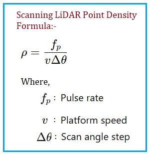
where:
- PRF = Pulse Repetition Frequency (Hz)
- V = Platform Speed (m/s)
- S = Scan Angle Step (radians)
About Scan Angle Step (S):
- It is the angular increment between successive laser pulses in a LiDAR system. It determines how densely the laser scans across the ground as the platform moves.
About Platform Speed (V):
- It is the speed at which the LiDAR platform (e.g., drone, aircraft) is moving during data collection. The platform speed affects the point density because it determines how quickly the laser pulses are emitted over the ground.
About Pulse Repetition Frequency (PRF):
- It is the number of laser pulses emitted by the LiDAR sensor per second. The PRF directly influences the point density, as a higher PRF allows for more pulses to be emitted over a given area, resulting in a denser point cloud. Conversely, a lower PRF reduces the number of pulses emitted, leading to a sparser point cloud
Applications/Benefits of LiDAR Point Density Calculation
- Survey Planning: Calculate the required point density to meet project specifications and ensure sufficient data resolution for mapping and analysis.
- Data Quality Assessment: Evaluate the point density of collected LiDAR data to determine if it meets the necessary standards for accurate modeling and visualization.
- Resource Optimization: Optimize flight parameters such as speed and scan rate to achieve the desired point density while minimizing survey time and costs.
- Project Feasibility: Assess the feasibility of a LiDAR survey by estimating point density based on available equipment and flight conditions.
- Comparative Analysis: Compare point densities across different survey areas or flight configurations to identify the best approach for data collection.
References for further study
- “LiDAR Survey Planning and Point Density Requirements” - An in depth article explaining how to plan a LiDAR survey based on point density requirements for various applications.
- “Comparative Analysis of LiDAR Point Densities” - A study on how to compare point densities across different survey areas or flight configurations to identify the best approach for data collection.
Advertisement


