LiDAR Point Density Calculator | Points per m² Formula
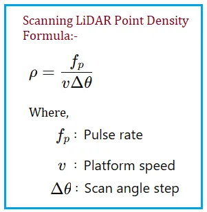
Calculate airborne LiDAR point density using flight speed, scan rate, and altitude. Ensure your geospatial project meets point per square meter requirements.
Advertisement
Trace every article connected to this tag across guides, explainers, and practical RF topics. This view is especially useful when the same concept spans multiple categories.
Articles
1
Showing
1-1
Pages
1/1
Where this tag appears most
Open the categories where this topic shows up most often.
Advertisement
Tagged Articles
Showing 1-1 of 1 articles tagged with Lidar Point Density.
Calculate airborne LiDAR point density using flight speed, scan rate, and altitude. Ensure your geospatial project meets point per square meter requirements.
Advertisement