Bathymetric LiDAR Depth Calculator | Snell's Law Formula
Advertisement
This calculator determines the depth of underwater features using bathymetric LiDAR technology. By inputting the time it takes for the laser pulse to return from the water surface and the bottom, along with the refractive index of water, you can calculate the depth of the seafloor or riverbed. This is essential for applications like coastal mapping, underwater archaeology and habitat monitoring. The calculator also accounts for refraction at the air water interface using Snell’s Law to ensure accurate depth measurements.
Example:
Input:
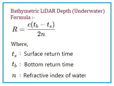
- Surface Return Time (micro-seconds): 1
- Bottom Return Time (micro-seconds): 1.5
- Refractive Index of Water: 1.33
Output:
- Water Depth in meters: 56.35
Bathymetric LiDAR Depth Formula
Applications/Benefits of Bathymetric LiDAR Depth Calculation
- Coastal Mapping: Bathymetric LiDAR allows for high resolution mapping of coastal areas, including seafloor topography and underwater features.
- Underwater Archaeology: LiDAR depth calculations help archaeologists locate and study submerged artifacts and shipwrecks with precision.
- Habitat Monitoring: Bathymetric LiDAR can be used to monitor underwater habitats, such as coral reefs and seagrass beds, by providing accurate depth information.
- Flood Risk Assessment: Accurate depth measurements from bathymetric LiDAR can inform flood risk assessments and help in the design of coastal defenses.
- Navigation Safety: Bathymetric LiDAR can enhance navigation safety by providing detailed depth information for mariners, especially in shallow waters and near shorelines.
- Environmental Research: Researchers can use bathymetric LiDAR data to study sediment transport, erosion, and other coastal processes that impact ecosystems and human infrastructure.
References for further study
- “Bathymetric LiDAR Technology and Applications” - An in depth article explaining how bathymetric LiDAR works and its various applications in coastal mapping and underwater research.
- “Snell’s Law and Refraction in LiDAR Systems” - A comprehensive overview of how Snell’s Law is applied in LiDAR systems to correct for refraction at the air water interface, ensuring accurate depth measurements.
- “Bathymetric LiDAR Data Processing and Depth Calculation” - A technical paper detailing the data processing steps and formulas used to calculate underwater depth from bathymetric LiDAR measurements.