LiDAR Explained: Target Detection, 3D Mapping & Imaging
Advertisement
Introduction : LiDAR (Light Detection and Ranging) is transforming industries from autonomous vehicles to environmental monitoring. By using laser pulses to measure distances and generate highly accurate 3D models, LiDAR enables precise target detection, 3D mapping and imaging across diverse environments.
In this in depth article, we will explain how LiDAR works for two major use cases target detection and complex 3D mapping. We will also learn its core components, applications, advantages and future trends.
1. LiDAR as Target Detection System
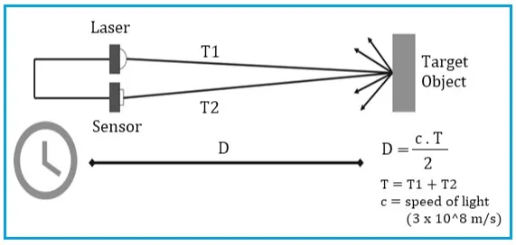
At its most basic level, LiDAR is a target detection system. It functions as an incredibly fast digital stopwatch that uses light instead of sound to identify how far away an object is and where it is located. Target detection refers to identifying and classifying objects within a scanned environment using LiDAR data. These targets can include Vehicles, Pedestrians, Buildings, Trees, Terrain features, Obstacles etc.
The most common method for target detection is Direct Time of Flight (dToF). Let us understand the process in steps.
- A laser emitter fires a pulse of infrared light.
- The pulse hits an object and reflects back. whether it’s a pedestrian, a warehouse wall, or a tree branch it reflects back to a high sensitivity sensor, such as a Silicon Photomultiplier (SiPM)
- The sensor measures the time (‘T’) taken for the return.
- Distance is calculated using the speed of light (‘c’ equals 3 x 10^8 meters per second) with millimeter precision.
- The distance formula is as follows. The division by 2 accounts for the round trip travel of the laser pulse.
When millions of such measurements are collected, they form a point cloud; a dense 3D dataset representing objects and terrain.
One of the greatest hurdles in target detection is the sun. Sunlight acts as “noise” that can drown out the laser’s signal. To solve this, modern LiDAR uses Multi shot technology.
Target detection must also be safe. Most commercial LiDARs operate at 905 nm or 1550 nm. Out of these, 905 nm is cost effective and uses standard silicon detectors. 1550 nm is considered “eye safe” and allows for higher power which translates to longer detection ranges.
2. LiDAR as 3D mapping and imaging system
While detecting a single point tells you how far something is, the real magic happens when you combine thousands of those points to create 3D Mapping and Imaging. This turns a simple distance measurement into a digital twin of the physical world.
LiDAR 3D mapping involves collecting millions of distance measurements to create precise digital elevation models (DEMs) and 3D terrain models. Following are different types of LiDAR mapping.
- Airborne LiDAR : Mounted on aircraft or drones.
- Terrestrial LiDAR : Ground based scanning systems.
- Mobile LiDAR : Mounted on moving vehicles.
- Bathymetric LiDAR : Used for underwater mapping
Creation of Point Cloud by LiDAR
There are different imaging outputs produced by LiDAR such as point clouds, intensity images, 3D surface models, digital elevation models and digital surface models. Let us understand how point cloud; highly accurate 3D representation of the environment is created by LiDAR.
To create an image, the LiDAR beam must move. This is called “scanning.” As the laser sweeps across a scene, it collects millions of individual data points. Each point has its own X, Y, and Z coordinate. When viewed together, these points form a Point Cloud. Unlike a standard 2D camera, this “image” contains depth data for every single pixel, allowing computers to understand the shape and volume of objects.
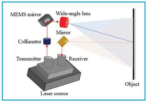
How the LiDAR “paints” this image depends on its architecture as follows.
- Mechanical & MEMS Scanning: These systems use rotating motors or vibrating micro mirrors to sweep a laser beam across the field of view. They provide high resolution images over long distances, making them the standard for autonomous vehicle navigation.
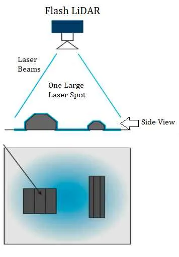
- Flash LiDAR: This works like a 3D camera. It floods the entire scene with a single “flash” of light and an array of sensors captures the whole image at once. While it has a shorter range, it is incredibly fast and has no moving parts, making it perfect for indoor robotics and gesture recognition.
Real World Applications
Following are some of the applications of LiDAR imaging across multiple sectors.
- Autonomous Transportation: Vehicles use 3D imaging to distinguish between a flat picture of a person on a billboard and a real pedestrian standing in the road.
- Environmental Surveying: Drones equipped with LiDAR can map forest canopies, measure coastal erosion or even see through dense vegetation to find archaeological ruins hidden on the ground.
- Industrial Monitoring: In agriculture and logistics, Static LiDAR can map the volume of grain in a silo or the contents of a liquid tank without ever touching the material.
Summary
LiDAR is more than just a rangefinder; it is a bridge between the physical and digital worlds. By mastering the art of Target Detection, LiDAR ensures safety and precision. By evolving into 3D Mapping and Imaging, it provides brain for next generation of autonomous machines. This allows LiDARs to navigate our world with level of detail that human eye simply cannot match.