Remote Sensing: 5 Advantages and Disadvantages
Advertisement
Remote sensing technology has transformed the way we collect and analyze data about the Earth. By using satellites and aerial sensors, remote sensing provides critical information for applications like agriculture, environmental monitoring, and disaster management. However, despite its many benefits, such as vast area coverage and real-time data collection, remote sensing has its limitations. In this guide, we will explore the advantages and disadvantages of remote sensing technology in various fields.
What is Remote Sensing?
- Sensor is the device used for sensing. It consists of optical components and a detector which records reflected and/or emitted energy from various objects on the earth.
- Remote sensing is acquiring data about an object without touching it. Specific satellites are used for this purpose.
- There are two main types of remote sensing satellites: passive and active.
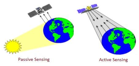
- Passive sensing receives emitted EM energy from various objects which is the result of the sun’s reflected energy from them. Based on received energy, various measurements have been carried out.
- Active sensing uses an EM source which transmits energy towards the Earth and receives reflected energy. Measurements have been carried out using these received energy values.
The figure depicts both active and passive remote sensing types.

- Usually in a remote sensing system, energy recorded by the on-board satellite sensor has to be transmitted to a processing station on the earth. Here the received data are processed into an image (in hardcopy and/or digital format).
- This processed image is interpreted either visually and/or digitally in order to extract various information about the target characteristics.
- Remote sensing has many applications such as agricultural (e.g., crop identification and estimation, soil study, soil mapping etc.) , Forest mapping, land cover mapping etc.
Advantages of Remote Sensing
- Images obtained using remote sensing satellites are used as permanent records which provide useful information in various wavelengths.
- It can be used for large area coverage analysis and repetitive coverage analysis (e.g., water and agriculture etc.).
- Data acquisition at various scales and resolutions can be performed with ease, which can be processed very fast using a computer in the lab.
- Passive remote sensing is unobstructive as it records based on EM radiation received from phenomena of interest.
- It detects natural calamities such as floods or forest fire or volcanic eruption so that immediate rescue operations and planning can be carried out.
Disadvantages of Remote Sensing
- The technique is very expensive for small areas requiring one time analysis.
- Specific training is needed in order to analyze the image data.
- It is difficult to prepare large scale maps from obtained satellite data.
- Repetitive aerial photographs are required for analysis of dynamic features. This increases overall cost to the system.
- The selection of sensors, mounting of sensors, collection of data and its timings are determined by human beings which may lead to errors if care is not taken.
- Remote sensing equipments require regular calibration; failing to do so will result in uncalibrated remote sensing data.
- Nearby active systems such as radar and laser interferes with the remote sensing system. This affects the phenomenon being analyzed.
- Certain cases are difficult to be distinguished by the sensor such as artificial grass and natural grass. Infrared light can distinguish them.
Conclusion
Remote sensing offers numerous advantages, including wide area coverage, frequent monitoring, and accessibility to remote locations. It provides valuable multi-spectral and multi-temporal data, supports cost-effective large-scale observations and is a non-intrusive method. However, it also has disadvantages such as resolution limitations, weather dependency, high initial costs, and data processing requirements. Balancing these advantages and disadvantages of remote sensing are crucial for optimizing the use of remote sensing in various applications and ensuring effective and accurate data collection and analysis.
Advertisement
 RF
RF


