
GPS Pseudorange Calculator & Formula | GNSS Distance Tool
Advertisement
The GPS Pseudorange Calculator helps you compute the apparent distance between a GPS satellite and a receiver using raw satellite data and time delay measurements. In GNSS (Global Navigation Satellite Systems), pseudorange refers to the approximate range measurement that includes real propagation distance plus timing and atmospheric error components. Accurate pseudorange data is essential for determining user position and clock offsets simultaneously.
GPS Pseudorange Calculator
INPUTS:
- True range = 20200000 m
- Receiver clock bias = 100- ns
- Satellite clock bias = - 20 ns
- Ionospheric delay = 5 m
- Tropospheric delay = 2.3 m
OUTPUTS:
- Pseudorange to satellite (meters) = 20200031
- Pseudorange to satellite (Km) = 20200.031
Note : You can also add Noise & multipath error (m) in the output “Pseudorange to satellite (meters)” to get more accurate result.
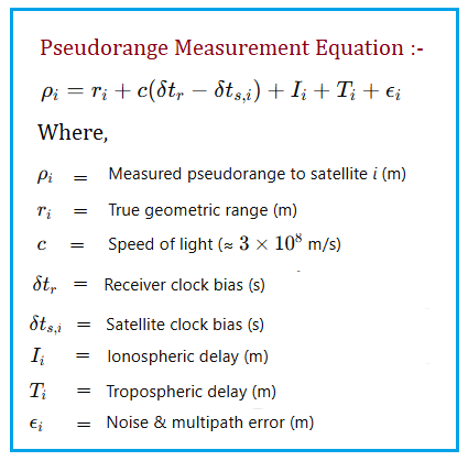
GPS Pseudorange Formula
Benefits/Applications
- Calculates the observed range between satellite and receiver for positioning.
- Helps correct satellite clock bias, ionospheric and tropospheric delays.
- Used in raw GNSS processing for research, smartphone GNSS decoding, and RTK/PPP solutions.
- Supports navigation, surveying, and geolocation analytics.
Summary: Understanding and computing pseudorange is the first critical step in GPS position computation. This calculator not only returns raw ranges but also teaches how corrections affect final position solutions.
Advertisement


