LLA to ECEF Converter Calculator & Formula
Advertisement
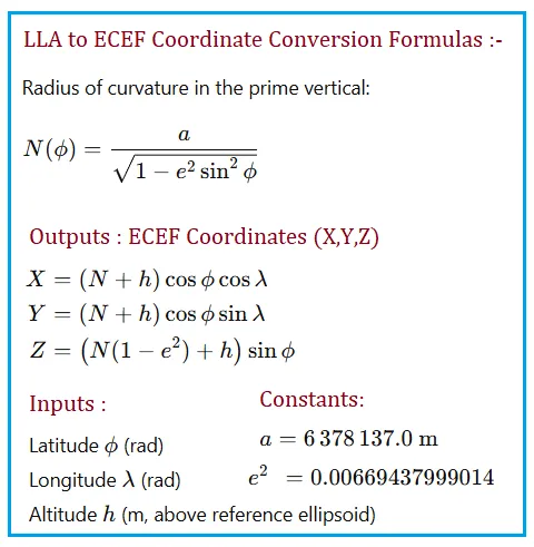
Geodetic coordinates viz. Latitude, Longitude, Altitude (LLA) are most intuitive for users, but internal GNSS solutions work in ECEF Cartesian coordinates. Converting between these systems is a cornerstone of GPS and geospatial engineering.
GPS LLA to ECEF Converter Calculator
INPUTS:
- Latitude (ϕ) = 40 degrees
- Longitude (λ) = -75 degrees
- Altitude (h) = 100 meters
OUTPUTS:
- Radius of Curvature (N) = 6386976.16 meters
- X = 1266345.73 meters
- Y = -4726066.62 meters
- Z = 4078049.85 meters
Constants:
- Semi-major axis (a) = 6,378,137
- Eccentricity squared (e^2) = 0.00669438
GPS LLA to ECEF Converter Formula
Benefits/Applications
- Transforms human friendly location into machine friendly ECEF format.
- Enables 3D geometric calculations and satellite distance computations.
- Used in UAV navigation, GIS conversions and coordinate transformation workflows.
Summary: This calculator bridges human and machine coordinate systems, enabling any GNSS data processing pipeline to compute precise geometric positions.