IRNSS: India's GPS Navigation System - Features and Applications
Advertisement
This article delves into IRNSS (Indian Regional Navigation Satellite System), which is essentially India’s version of GPS. We’ll explore its features, network elements, configuration, satellite constellation, applications, and the services it provides.
IRNSS is an independent Indian Navigation Satellite System designed to deliver GPS services to both public and private users within India and a region extending approximately 1500 km around the Indian territory. The entire system is a product of the Indian Space Research Organisation (ISRO).
ISRO Bangalore has spearheaded the development of IRNSS, with support from its various centers. The creation of this indigenous system paves the way for the development of IRNSS-compatible products, including receivers and test and measurement equipment.
The success of IRNSS hinges significantly on its spacecraft and ground stations. Once fully operational and stable (anticipated around 2017 or 2018), Indian users of GPS services will no longer need to rely on GPS services provided by the USA. This will drastically reduce delays in accessing these services on smartphones and tablets, meaning GPS apps will run much faster.

IRNSS Network Elements
The entire IRNSS system is structured into three key elements:
-
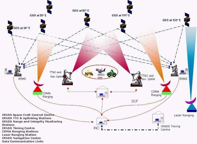
Space Segment: This comprises a total of 7 navigation satellites. Three are positioned in Geostationary Orbit (GEO) at 34°, 83°, and 132° East. The remaining four are in Geosynchronous Orbit (GSO) at an inclination of 29°, crossing longitudes 55° and 111° East. Table 2 (below) lists the navigation satellites launched by India to provide GPS services within the Indian region. SPS (Standard Positioning Service) uses BPSK modulation, while PS (Precision Service) employs BOC (Binary Offset Carrier) modulation.
-
Ground Segment: This segment incorporates IRIM (IRNSS Ranging and Integrity Monitoring Stations), INC (IRNSS Navigation Control Center), SCC (Spacecraft Control Centre), IRNSS telemetry and command stations, and CDMA ranging stations. Each of these ground segment systems performs specific functions critical to the maintenance and management of the entire IRNSS GPS system.
-
User Segment: This consists of specifically designed IRNSS receivers. These receivers are available in single and dual-frequency variants and continuously track the satellite constellation. End-users include individuals using GPS services for location finding via maps, and government agencies seeking to pinpoint the precise location of GPS users.
IRNSS Features
| Feature | IRNSS Support |
|---|---|
| Accuracy | 10 to 15 meters with a single antenna; 5 to 8 meters with a dual antenna (with two frequencies) |
| Frequency Bands | L5 Band (1176.45 MHz); S Band (2492.028 MHz) |
| Service Area | Longitude 40° East to 140° East and latitude +/-40° |
| Coverage | Approximately 1500 Km from the Indian boundary |
| Total Satellites | 7 total (3 GEO, 4 GSO) |
| Services Offered | SPS (Standard Positioning Service); PS (Precision Service) |
| IRNSS receiver G/T | -27 dB/K |
Table 1: IRNSS Features
IRNSS Satellites
The following table lists the IRNSS satellites launched by India for GPS navigation. These satellites form the IRNSS constellation in space. All these satellites were launched by ISRO using the PSLV launch vehicle.
| Name | Launch date |
|---|---|
| IRNSS-1A | July 1, 2013 |
| IRNSS-1B | April 4, 2014 |
| IRNSS-1C | Oct. 16, 2014 |
| IRNSS-1D | March 28, 2015 |
| IRNSS-1E | Jan. 20, 2016 |
| IRNSS-1F | March 10, 2016 |
| IRNSS-1G | April 28, 2016 |
Table 2: Satellites launched by INDIA for IRNSS services
IRNSS GPS INDIA Applications
IRNSS offers a wide array of applications:
- High accuracy in locating positions.
- The entire satellite constellation is consistently visible to IRNSS receiver users.
- Ionospheric correction messages are provided.
- Vehicle tracking and management.
- Disaster management.
- Terrestrial, aerial, and marine navigation.
- Navigation services for drivers.
- Map data collection for analysis.
- GPS integration in smart devices, including mobile phones, smartphones, tablets, and other gadgets.
Advertisement
 RF
RF


