LEO vs GEO Satellites: Key difference between LEO and GEO
Advertisement
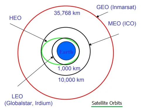
Introduction : Satellites are classified based on their orbital altitudes, with Low Earth Orbit (LEO) and Geostationary Earth Orbit (GEO) being two of the most widely used. LEO satellites orbit close to Earth, typically at altitudes between 160 to 2,000 km, while GEO satellites orbit at a much higher altitude of about 35,786 km above the equator, maintaining a fixed position relative to Earth. Each orbit type has its own advantages and disadvantages, making them suitable for different applications such as communications, Earth observation, weather forecasting, and satellite internet services. The figure depicts different satellite orbit types.
LEO (Low Earth Orbit)
LEO satellites orbit the Earth at altitudes ranging from 160 to 2000 Km. Due to their proximity to the Earth, they offer low latency and high data transmission speeds, making them suitable for applications like remote sensing, satellite phones, IoT connectivity and Earth observation. However, they have a short orbital period (~ 90 to 120 minutes) and small coverage area, requiring a constellation of satellites to provide continuous global coverage.
GEO (Geostationary Earth Orbit)
GEO satellites are positioned at 35786 km above the equator, matching the Earth’s rotation to remain fixed over one location. This makes them ideal for TV broadcasting, weather monitoring and large scale communication networks, as they offer broad coverage (one third of the Earth) and constant visibility to a fixed ground location. However, the latency is higher (~ 600 ms) due to the large distance, and they have limited coverage at polar regions.
Difference between LEO and GEO
| Parameters | LEO | GEO |
|---|---|---|
| Full form | Low Earth Orbit | Geostationary Orbit |
| orbit altitude | 160 to 2000 Km | 36000 Km |
| Constellation | Each satellite can cover lesser region, need more satellites in a constellation to cover larger region | One satellite can cover almost an entire continent on the Earth |
| Satellite Cost | Low | High |
| Movement | Very fast, subject to doppler effect | Appears stationary, orbits at the same rate as the Earth |
| Lifetime | 3 to 5 Years, requires periodic launches | About 15 years |
| Communication | One Way (mainly Uplink) | Two way |
| Spectrum | Typically uses frequencies below 1 GHz or unlicensed spectrum | Licensed Spectrum (S-Band/L-Band) for MSS/IoT Applications. |
| Antenna on device | Complex and larger due to simpler and cheaper satellite design | Simple and cheaper antennas, large dish (for old satellites) |
| End to End Latency | ~30-50 ms | ~500-600 ms |
| Round trip link latency | ~20-40 ms | 600 ms |
| Examples | Starlink (SpaceX), OneWeb | INSAT Series, Inmarsat, Arabsat |
Conclusion: In summary, LEO satellites offer low latency, high speed communication and better resolution imaging, but require constellation deployment and frequent handoffs due to their fast movement. On the other hand, GEO satellites provide continuous coverage over a large area with fewer satellites, making them ideal for broadcast and weather services, though they suffer from higher latency and poorer signal strength in polar regions. Understanding the differences between LEO and GEO is essential for selecting the right satellite orbit based on mission requirements, cost and coverage needs.