RTT (Round Trip Time) Calculator for 5G NTN
Advertisement
This page provides RTT (Round Trip Time) calculator for 5G Non-Terrestrial Networks (NTN). It calculates RTT for nadir case as well as off-nadir case between satellite and User Equipment (UE). Satellite can be in Geostationary Earth Orbit (GEO), Medium Earth Orbit (MEO) or Low Earth Orbit (LEO).
5G NTN RTT Calculator (Nadir Case)
In the nadir case, the user terminal (UE) and the gateway are located directly beneath the satellite, forming a straight line through the Earth’s center. The satellite to ground distance is minimal and equal to the satellite’s altitude. Thus, the one-way propagation delay is simply the altitude divided by the speed of light, and the RTT is twice that value.
Nadir geometry therefore represents the shortest possible RTT for a given orbit and serves as the reference baseline for system design and latency budgeting in 5G NTN.
EXAMPLE:
- INPUTS:
- Satellite Altitude = 1200 Km (LEO - 1,200 km to 2,000 km, MEO - 8,000 km to 20,000 km, GEO - 35,786 km)
- OUTPUTS:
- RTT (Nadir) = 16 ms
5G NTN RTT Calculator (Off-Nadir Case)
In the off-nadir case, the UE or gateway communicates with the satellite at an elevation angle less than 90°, meaning the link path is slanted instead of vertical. This increases the slant range, and therefore, the signal’s propagation time.
For low elevation angles (e.g., 5 to 20 degrees), the slant range can be several times the satellite altitude, adding multiple milliseconds to the RTT in LEO systems and tens of milliseconds in MEO or GEO.
Off-nadir RTT also varies dynamically as the satellite moves across the sky, making it a key factor in link adaptation, beam handover and QoS management in 5G NTN environments.
EXAMPLE:
- INPUTS:
- Satellite Altitude (h) = 1200
- UE elevation angle (ε) = 20 degrees
- OUTPUTS:
- Earth Central Angle (β) = 17.74 degrees
- UE to Satellite distance (dus) = 2455.47 Km
- RTT (Off-Nadir, 30°) = 24.36 ms
RTT (Round Trip Time) Formula
The following equation (or formula) is used for this 5G NTN RTT calculator:
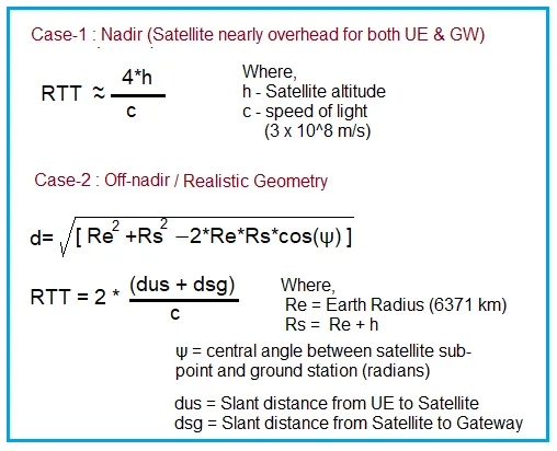
Note: Add processing delay at the satellite and gateway to the calculated RTT for more accurate results. Asuumption: For simplicity, assume the satellite to gateway link (dsg) equals the satellite altitude (h). This represents the gateway being directly below the satellite (nadir position).
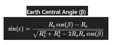
| Symbol | Meaning | Typical Unit |
|---|---|---|
| ε | UE elevation angle above local horizon | degrees or radians |
| β | Earth central angle between UE and satellite subpoint | radians or degrees |
| Re | Earth radius | km (≈ 6371 km) |
| h | Satellite altitude above Earth surface | km |
| Rs = Re + h | Satellite orbital radius (from Earth’s center) | km |
Reference Table for RTT (Round Trip Time) Values
| Orbit | h(Km) | UE Elev. (Degrees) | d_UE->Sat (Km) | d_Sat -> GW (Km) | RTT (Prop), ms |
|---|---|---|---|---|---|
| LEO | 1200 | 20 | 2455.5 | 1200 | 24.4 |
| LEO | 1200 | 5 | 2572.5 | 1200 | 31.8 |
| MEO | 10000 | 20 | 13058.1 | 10000 | 153.7 |
| GEO | 35786 | 10 | 40581.2 | 35,786 | 509.1 |
| GEO | 35786 | 45 | 37410.6 | 35786 | 488.0 |
References :
- MathWorks® — Aerospace Toolbox Documentation
- Mathworks.com