 RF
RFGIS vs GPS | difference between GIS and GPS
Advertisement
GIS (Geographic Information System) and GPS (Global Positioning System) are two distinct but closely related technologies used for managing and working with geographic and location based information.
GIS is a system for managing and analyzing geographic data, while GPS is a satellite-based navigation system that provides precise location and time information.
These technologies are often used in conjunction with each other to enhance spatial analysis, mapping, and location based services.
GIS - Geographical Information System
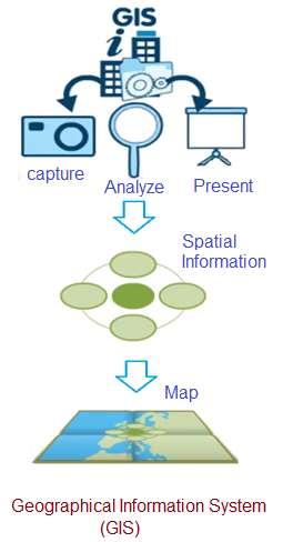
GIS stands for Geographic Information System. It is a computer-based system designed to capture, store, manage, analyze, and visualize geographic data or spatial information. In essence, GIS is used to work with data that has a geographical or spatial component. GIS allows users to create, manipulate, and analyze maps and spatial data. It can combine various types of data, such as maps, satellite images, survey data, and more, to provide insights and support decision-making. GIS is widely used in fields like urban planning, environmental management, disaster response, and business analysis.
- The software program which enables users to store and manipulate large amounts of data from GPS and other sources.
- It is software systems with capability for input, storage, manipulation/analysis. It displays geographic (spatial) information in various output formats such as maps, graphs or charts.
- It is a system which deals with all types of geographically referenced data.
- GIS software runs on powerful servers to mobile software.
- There are three common representations of spatial data used in GIS viz. vector, raster and triangulated.
GPS - Global Positioning System
GPS stands for Global Positioning System. It is a satellite-based navigation system that provides accurate location and time information anywhere on Earth. GPS relies on a network of satellites orbiting the Earth to transmit signals that can be received and used by GPS receivers. GPS receivers determine their precise location on Earth by calculating the time it takes for signals from multiple GPS satellites to reach them. This location information can be used for various purposes, including navigation, tracking, surveying, and more.

- As shown in the figure, GPS system consists of total 28 satellites orbiting around the earth divided among six different orbits. The satellites are positioned at the height of about 20,180 km. As the orbits, satellites are inclined to about 55 degree with equator. This makes four satellites visible all the time from any location on the earth.
- A satellite system which projects information to GPS receivers on the ground. This enables users to determine latitude and longitude coordinates.
- It is a system of earth-orbiting satellites which can provide precise information in 100 meters to sub-cms.
Difference between GIS and GPS
The following table outlines the key differences between GIS (Geographic Information System) and GPS (Global Positioning System). Though GIS and GPS are distinct technologies, they are often used together in various applications, with GPS providing location data that can be incorporated into GIS for spatial analysis and mapping.
| Parameters | GIS | GPS |
|---|---|---|
| Definition | A system which is used for capturing, storing, analyzing and displaying spatial data. | A satellite based navigation system that provides location and time information anywhere on the Earth. |
| Functionality | Manages and analyzes geographical data which allows users to create maps, perform spatial analysis and make informed decisions. | Provides precise location and time information using signals from a network of satellites. |
| Data | Utilizes wide range of geospatial data sources, including maps, aerial imagery, satellite imagery etc. | Relies on signals received from constellation of GPS satellites to determine receiver’s position and time. |
| Purpose | Used for mapping, spatial analysis, urban planning, environmental monitoring, disaster management, decision making etc. | Primarily used for navigation, location based services, vehicle tracking and surveying etc. |
| System components | Includes software, hardware and data. It requires data collection, storage and analysis tools. | Comprises satellites in space and GPS receivers on the ground or devices like smartphones with built-in GPS capabilities. |
| Accuracy | It varies based on quality of input data and analysis methods. It can be highly accurate. | Provides accurate location information, typically within a few meters, but can be less accurate in challenging environments such as dense urban areas or deep canyons |
| Real time tracking | Can be used for real time tracking but requires real time data feeds and connectivity to GPS devices. | Provides real time tracking of the receiver’s position. |
| Examples | Software such as ArcGIS, QGIS. Google Earth | Devices such as GPS receivers, smartphones, GPS enabled vehicles |
| Applications | Urban planning, disaster response, environmental monitoring | Navigation, Geocaching, location based gaming |
Conclusion : After comparing GIS vs GPS, we can conclude that GIS (Geographic Information System) is a computer-based system for managing and analyzing geographic data, enabling users to create maps, perform spatial analysis, and make informed decisions by integrating various spatial datasets.
In contrast, GPS (Global Positioning System) is a satellite-based navigation system that provides precise location and time information anywhere on Earth by receiving signals from a network of orbiting satellites.
While GIS focuses on data management and spatial analysis, GPS primarily serves for real-time positioning and navigation applications, and the two are often used together to enhance geographic information management and location-based services.
Advertisement


