 RF
RFGIS Data vs. Geodatabase: Key Differences Explained
Advertisement
This article clarifies the difference between GIS data and Geodatabase datasets.
What is GIS (Geographical Information System)?
GIS stands for Geographical Information System. The term “Geodatabase” combines “Geo,” referring to spatial data, and “database,” referring to a Relational Database Management System (RDBMS).
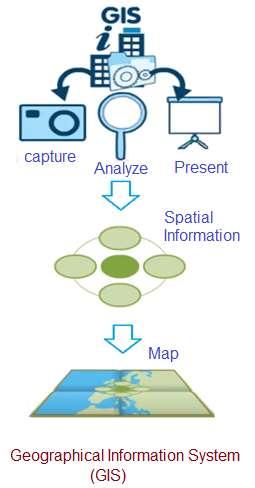
- It’s a business information management system that captures, analyzes, and represents spatial information on a map.
- It empowers users to make better decisions based on geography.
- Viewing data on a digital map is more user-friendly than using spreadsheets.
- GIS software can run on various devices, from powerful servers to mobile phones.
- GIS tools help visualize geographic data as maps, graphs, or charts, making patterns and trends easier to identify than in spreadsheets.
- GIS functions include data entry, display, management, information retrieval, and analysis.
- A data model in GIS is a mathematical construct representing geographical objects or surfaces as data.
- Three common spatial data representations in GIS are vector, raster, and triangulated irregular networks (TIN). Each is suited for specific information types and analyses.
- GIS is a form of geospatial technology, alongside GPS, satellite remote sensing, and geofencing.
What is a Geodatabase?

- ESRI® ArcGIS® applications (like ArcMap™, ArcCatalog™, and ArcToolbox™) work with geodatabases, coverages, and shapefiles.
- The term combines “geo” (spatial) and “database” (RDBMS).
- It’s the native data storage and management framework for ArcGIS.
- It serves as an organizational tool for storing and managing data.
- It provides access to advanced GIS capabilities.
GIS Data vs. Geodatabase Dataset: Key Differences
The following table highlights the differences between GIS data and Geodatabase datasets:
| GIS data | Geodatabase dataset |
|---|---|
| Coverage | Feature dataset containing feature classes |
| Shapefile | Feature class |
| Raster data (e.g., satellite images, air photos, scanned maps, digital pictures) | Raster dataset and/or raster catalog |
| CAD data | Feature dataset containing feature classes |
| Surface modeling or 3D data | Terrain |
| Utility network data (e.g., water systems, gas pipelines, telecom networks) | Geometric network |
| Transportation network data (e.g., street networks) | Network dataset |
| GPS coordinates | Table of x, y coordinates that can be generated into a feature class |
| Survey measurements | Cadastral fabric table |
Advertisement


