
GPS Tutorial: Basics, Applications and System Overview
Advertisement
GPS stands for Global Positioning System. It is mainly used to determine location, speed, and time of users on Earth.
This tutorial covers GPS basics, GPS applications, references, and provides a link to GPS chips/modules manufacturers. GPS (Global Positioning System) is one of the GNSS (Global Navigation Satellite System).
GPS has a constellation of 31 satellites in service and is based on CDMA technology.
GPS System Overview
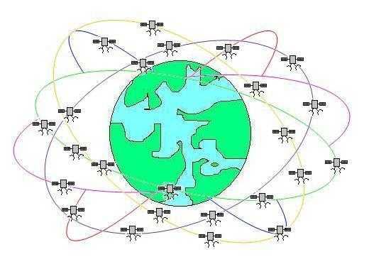
Fig. 1: GPS system
As shown in the GPS system consists of a total of 28 satellites orbiting around the earth, divided among six different orbits. The satellites are positioned at a height of about 20,180 km. The orbits are inclined to about 55 degrees with the equator. This ensures that four satellites are visible at all times from any location on Earth, as shown in the figure below.
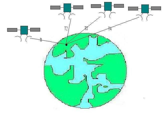
Fig. 2: GPS system to determine position in 3D
As shown in Figure 2, four satellites are needed to determine a position on Earth in 3-dimensional space.
Let’s see how a satellite is used to determine distance by using the time interval of a pulse to reach from satellite to the Earth.
Using 4 satellites, 4 unknown parameters can be determined which include latitude, longitude, height and timing error. As shown in the figure GPS receiver measures T1, T2, T3 and T4.
- The arrival times of signals from the satellites at the GPS receiver.
- These are measured against its internal clock. The more information the receiver has, the faster it can get a position.
GLONASS
As mentioned, GLONASS stands for Global Navigation Satellite System.
Why do we need A-GPS?
-
Time aspect: Approximately 38 seconds is too long for the end user to wait for a fix.
- Option 1: Keep the GPS on, track satellites, and keep ephemeris/GPS time up to date to be always in a hot start condition.
- Problem: Power consumption.
- Option 2: Somebody provides relevant information whenever the user wants to use his/her GPS receiver.
-
Sensitivity aspect:
- Cold start: Physical limit to decode data around -148dBm.
- The GPS signal is below this limit when the user is in a building, for example.
- Getting information on satellites allows the GPS receiver to break the physical barrier.
- These are the reasons for having Assisted GPS = A-GPS
A-GPS User Plane vs Control Plane
User Plane
- Uses the Packet Switched network (TCP/IP) capability to bypass the Switched Circuit infrastructure.
- Modification of cellular network is not required.
- Does not support location of emergency calls (in v1.0).
Control Plane
- Uses the Circuit Switched network for assistance data and communication
- RRLP for GSM (2G)
- RRC for WCDMA (3G)
- Requires updates to several network elements.
- Supports location of emergency calls.
- An alternative to A-GPS is predicted/extended ephemeris.
- But: ephemeris only, not position, visible satellite list, etc.
A-GPS Protocols
SUPL (Secure User Plane Location)
Secure User Plane Location is specified by OMA. OMA Secure User Plan Location as per document SUPL 1.0,V1_0-20070615-A.
A-GPS Protocols, Control Plane, RRLP, GSM networks
- Radio Resource LCS Protocol
- 3GPP ref: 44.031, v5.12.0
- Test cases: 34.171 (OR 25.171) / 51.010 conformance specifications
GPS Applications
GPS is used for a wide variety of applications which include Marine, Agriculture, mobile handsets, ATM, railways, aviation, space, survey, timing, etc.
GPS References
Visit following link for official information on GPS which includes standards, specifications and applications from the US Government. https://www.gps.gov/
Advertisement


