
GPS - Global Positioning System Basics
Advertisement
GPS avionic system is a long range navigational aid that stands for Global Positioning System. It provides aircraft position fix in three dimensions (3D). This technology is arguably the most precise system used in navigation by civilian and military aircrafts.
To understand why GPS is so effective, we first need to realize that there’s generally a tradeoff between position fix accuracy and the coverage area in navigation systems. We usually can’t have the best of both worlds. However, satellites operate at the UHF band, allowing for accurate position fix readings. To ensure a large and excellent coverage area, GPS transponders are placed far away in outer space, roughly 20,000 km from the Earth’s surface. As a result, GPS becomes an exceptional navigation tool, primarily due to its accurate position fix and large coverage area.
To obtain a 2D position fix, we need at least three satellites. For a 3D fix, a minimum of four satellites are needed. Logically, it might seem that the number of satellites should equal the number of dimensions for an accurate fix calculation. Technically, that’s correct. However, from a practical and cost-effective standpoint, we always require an extra satellite.
Number of satellites = Number of dimensions + 1
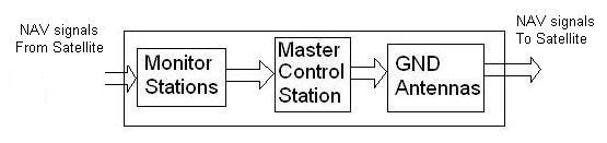
GPS ground facilities consist of monitor stations, a master control station, and ground stations used for both transmitting and receiving.
- Monitor stations: There are six monitor stations worldwide. They receive navigation signals from satellites and transmit them to the master control station for processing.
- Master control station: There is one master control station. Once or sometimes twice a day, the master control station determines any navigation adjustments or updates needed and forwards them to the ground antennas. These updates include orbital information, clock synchronization, and the status of the ionosphere layer.
- Ground antennas: There are approximately four ground antennas. They receive updates from the master control station and emit signals to the satellites.
GPS in Space
GPS satellites have the following features:
- Operate in various frequency ranges in UHF (L band).
- The orbital planes-6, Inclination-55 Degree, number of active satellites per plane are 4
- Position or altitude of satellites is about 10988 nm (20350 Km).
- A minimum of five satellites are in view at all times.
- The speed of a GPS satellite is about 11265 Km/hr.
- Solar radiation is the source of energy used by the solar arrays of the satellite. Onboard batteries are used during periods of darkness and solar eclipses.
- Each satellite contains either 3 or 4 atomic clocks. Only one of the clocks is actively used; the others remain on standby in case of an emergency or during maintenance.
- At all times, a total of 24 satellites must remain active to ensure worldwide coverage. The remaining 5 satellites are there for backup in case an unexpected malfunction occurs or a deliberate shutdown is forced for maintenance.
- Total coverage angle is about twice of 13.84 degrees.
- Satellites need to be re-positioned to their original predefined location using small onboard rocket boosters once a year, leading to a downtime of about 12 hours.
- Each GPS satellite transmits three signals: Pseudo-random code (PRC), Ephemeris data, and Almanac data.
- PRC contains the satellite ID, as each satellite has a unique PRC. The PRC is used to calculate the time it takes a signal to go from the satellite to the GPS receiver and is often referred to as a time signal.
- Ephemeris data contains the satellite’s position with respect to time.
- Almanac data contains information about the satellite’s status.
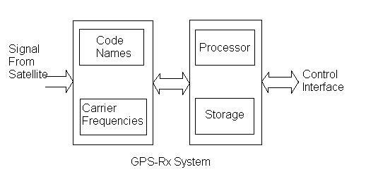
GPS Receiver (Rx) System in Aircraft
The GPS Rx system has the following features:
- Operates in the UHF band.
- GPS-Rx will observe data form at least 4 SATs in order to solve for the unknowns using the 4 equations
- The storage part of the Rx, which is updatable, contains a database with information about Airspace, Airports, navigation facilities etc.
- The main purpose of GPS is to calculate Aircraft position fix; however other output parameters are also derived such as TAS and Heading, GS and Track, WS and WA, distance to next WPT and/or to destination, ETA to next WPT and/or to destination, moving map display, Intensity of each signal received, Condition of each satellite tracked.
Advantages of GPS
- GPS is the most accurate NAV system ever invented.
- GPS provides continuous real-time navigation information.
- GPS is an all-weather system.
- GPS is available 24/7 to the international community.
- GPS is available free of charge without any subscription or license.
- Unlimited users can take advantage of GPS without degradation of the signals quality.
- For military activities, GPS can hit the target without causing major collateral damages.
Disadvantages of GPS
- Satellites use atomic clocks, and they are very precise; however, sometimes discrepancies do happen and hence time measurement errors.
- The satellites should generally maintain their predefined orbital positions; however, drifts do occur due to gravitational pulls (earth, moon, sun).
- The ionosphere and troposphere lead to the slowing down of signal propagation speed. This rate is variant and non-constant, which leads to complications in the correction/compensation.
- The GPS-Rx will detect the desired NAV signals; however, the signal might be slightly distorted with noise due to the wireless nature of the system.
- Ideally, we want signals to go straight from satellite to the GPS receiver; however, on occasions, the signals get bounced, and the Rx will detect these bounced signals.
- It is very costly to maintain the GPS constellation annually.
Advertisement


