GPS Satellites: Components, Functions, and Applications
Advertisement
Global Positioning System (GPS) satellites are a constellation of satellites orbiting the Earth. They provide location and timing information to a wide range of users across the world. The system is owned and operated by the United States government. There are three segments in the Global Positioning System: the space segment (GPS satellites), the control segment (ground stations comprised of a master control station, monitor stations, and ground control stations), and the user segment (GPS users).
The space segment consists of a total of 28 operational satellites around the Earth in 6 different orbital planes. The orbits are approximately 20,180 km above the surface of the Earth and are inclined at 55 degrees with the equator. A GPS satellite usually takes about 12 hours to complete one round of its orbit, but due to the rotation of the Earth, it takes about 24 hours for the GPS satellite to return to its originating place in the orbit. A minimum of four GPS satellites are needed to determine a position in 3D space.
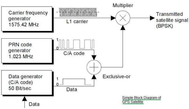
GPS Satellite Block Diagram
The GPS satellite transmits the following information in a navigation message at 50 bps:
- Satellite time and synchronized signals
- Orbital data
- Time correction information
- Approximate orbital data for all satellites
- Data on the ionosphere
- Correction signals to calculate transit time of signal
- Information on satellite health

A GPS satellite takes 12.5 minutes to transmit all the information. This navigation message is used by the GPS receiver to determine the transmission time of all the satellite signals, as well as the exact position of the satellite at the time of transmission.
Each GPS satellite transmits a unique signature, which is a pseudo-random noise (PN) sequence of 1023 zeros and ones, lasting 1 ms. This unique PN sequence helps the GPS receiver identify which satellite in the constellation the received signal is from. It also aids the GPS receiver in performing transit time measurements.
Figure 1 (above) depicts a simplified block diagram of a GPS satellite. It includes four accurate atomic clocks. Useful time pulses/frequencies are derived from the resonant frequency of one of the atomic clocks, including:
- 50Hz pulse for data
- C/A Code pulse (Coarse/Acquisition) which modulates data using EX-OR
- Frequency of L1 carrier (1575.42MHz)
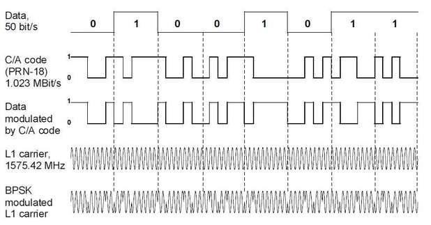
The data modulated by the C/A code then modulates the L1 carrier using Binary Phase Shift Keying (BPSK). This results in a 180-degree change in the L1 carrier phase corresponding to a change in the modulated data.

Figure 2 (above) illustrates the waveforms of a GPS satellite at different modules.
Atomic clocks require a stability greater than about . As mentioned, the basic frequency of 10.23 MHz for the GPS satellite is derived from the resonant frequency.
GPS Satellite Functions and Applications
GPS satellites, as part of the Global Positioning System, are used to determine:
- One’s location (longitude, latitude, height coordinates) with an accuracy ranging from 20 meters to 1 mm.
- The precise time (world time, Universal Time Coordinated - UTC) with an accuracy ranging from 60 ns to 1 ns.
Other parameters that can be derived from the 3D position and exact time include:
- Speed
- Acceleration
- Course
- Local time
- Range measurements
GPS satellite technology is widely used in the following domains:
- Science and Research
- Commerce and Industry
- Agriculture and Forestry
- Communication Technology
- Tourism and Sports
- Military
GPS Satellite Manufacturers
Some of the manufacturers of GPS satellites and their parts include:
- Lockheed Martin Corporation
- Boeing Space Systems
- AeroAstro L.L.C.
- Alcatel Space
- Alenia Spazio
- Amptek
- Arde
- COM DEV
- Credowan
- EaglePicher
- M/A-COM
- Saab Ericsson Space
Other countries and organizations have developed their own satellite navigation systems, including the Russian GLONASS, European Galileo, Indian IRNSS, and Chinese BeiDou systems.
Advertisement
 RF
RF


